What causes landslides in Big Sur area? New study analyzes 'active coastline'
Published in News & Features
SAN LUIS OBISPO, Calif. — The Big Sur coastline is ever-changing.
Waves strike the base of the cliffs, taking sediment with them. Meanwhile, rain also loosens sediment across the rocky coastline, making it more vulnerable to landslides. The highway — a long scar cut across the cliffs — is periodically blocked by landslides and washouts.
Now, a study released on Wednesday reveals how wave action and rain work together to erode the cliffs beneath Highway 1. It did not look at impacts above the highway.
“Cliff erosion follows a cyclical process in which waves erode the base of the cliff, destabilizing it and priming it for failure during storms,” study co-author and geologist Helen Dow told The Tribune.
The study, published in Volume 13 of the AGU Earth and Space Science Journal, analyzed an 8-mile stretch of the Big Sur coastline below Highway 1 from January 2017 to May 2023.
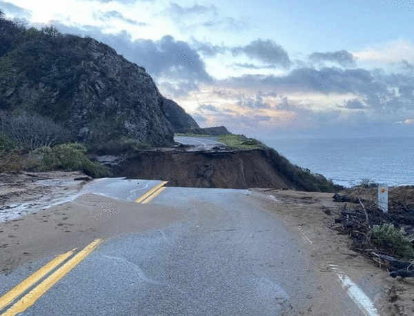
The study area — from Anderson Canyon to Gamboa Point — is located north of the three major landslides that recently closed portions of Highway 1: the Dolan Slide, Regent’s Slide and Paul’s Slide.Regent’s Slide Location on Highway 1 Regent’s Slide on Highway 1
This map shows the location of the Regent’s Slide along the Big Sur Coast, including the surrounding areas like Santa Cruz, Monterey, Cambria, and San Luis Obispo. Map created with the assistance of ChatGPT.
The researchers conducted 33 surveys during that seven-year period by taking aerial photos of the coast from an airplane. Then, they used those photos to create 3D models of the cliff face to measure how much erosion occurred between each flight.
On average, the cliff face eroded by 0.1 to 31.5 centimeters per year, depending on the location, Dow said. This came to an average cliff retreat rate of about 2 centimeters per year.
Previously published rates for the region were measured at 20 centimeters per year from 1942 to 1994, she said. But that data included large landslides, while this study did not.
It’s important to quantify erosion on the cliffs below the highway, Dow said, because “that might also help us understand the behavior of these larger landslides up slope.”
“What makes Highway 1 through Big Sur an engineering challenge is I think exactly what makes it stunning: It’s an active coastline,” she said.
According to the study, waves are primarily responsible for erosion of the lower cliffs, from 2.75 meters above the water line to 16.5 meters. This destabilizes the cliffs, making the upper cliffs more vulnerable to erosion during rainstorms.
Landslides were more likely to occur in the upper cliffs, above 16.5 meters, when the lower cliff was already steepened by wave action, Dow said.
“Wave erosion at the base is driving the instability,” she said. “The upper cliff tended to fail in locations where there had been prior erosion down slope.”
Because of this, Dow said it’s likely that large landslides triggered by storms were initiated by wave erosion in prior years.
Meanwhile, it was common to see erosion occur beside existing slope failures. For example, a large landslide in 2017 showed signs of down-slope erosion before the large landslide.
“Small amounts of erosion can lead to larger slides, and larger slides can evolve, leading to additional failures,” the report said.
The study period included three above-average rainfall years, 2017, 2019 and 2023.
The largest amount of cliff erosion happened in 2023, the wettest rain year. Slightly less erosion occurred during the second-wettest year of 2017, followed by the third-wettest year of 2019, the report said.
The study identified that cliff erosion is a cyclical, ongoing process, Dow said.
“While the westward location of the Big Sur coastline might shift a little through time, its overall shape will probably be relatively steady in time,” Dow said. “So hopefully that’s reassuring for the state of Highway 1.”
_____
©2026 The Tribune (San Luis Obispo, Calif.) Visit at www.sanluisobispo.com. Distributed by Tribune Content Agency, LLC.


Comments