Hurricane Erin back to Cat 4 near Bahamas as NHC tracks system following behind
Published in Weather News
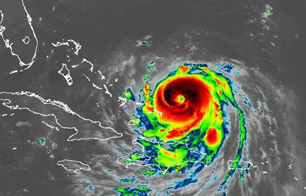
ORLANDO, Fla. — Hurricane Erin on Monday reinvigorated as a major Category 4 storm as it moved near the Bahamas while the National Hurricane Center increased the odds a system following in the Atlantic could become the season’s next tropical depression or storm.
As of the NHC’s 8 a.m. advisory, the center of Erin was located about 115 miles north-northeast of Grand Turk Island and 890 miles south-southeast of Cape Hatteras, North Carolina moving northwest at 13 mph with maximum sustained winds of 130 mph, which maintains its Category 4 status. It had fallen to a Category 3 hurricane with 125 mph most of Sunday.
“A gradual turn to the north is expected later today and on Tuesday,” said NHC senior hurricane specialist John Cangialosi. “On the forecast track, the core of Erin is expected to pass to the east of the southeastern Bahamas today and move between Bermuda and the east coast of the United States by the middle of the week.”
Topical storm warnings remain in place for the Turks and Caicos and the southeast Bahamas while a tropical storm watch was issued for the central Bahamas. The NHC noted interests in the northwestern Bahamas, North Carolina Outer Banks and Bermuda should monitor the progress of Erin.
The storm became the season’s first hurricane at 11 a.m. Friday, with 75 mph winds, but grew to a “catastrophic” Category 5 hurricane in just one day undergoing rapid intensification that had sustained winds of up to 160 mph. It began to lose intensity late Saturday after pushing just north of the northern Leeward Islands.
“Deep convection has been increasing in intensity and symmetry, and it seems likely that Erin will strengthen today,” Cangialosi said. “The intensification is likely to end by tonight due to some increase in shear and a broadening of the inner core wind field. Slow weakening seems likely beginning Tuesday, but it should be emphasized that Erin is expected to remain a powerful hurricane through the week.”
The system’s wind field began to expand on Sunday.
Hurricane-force winds extend out 80 miles while tropical-storm-force winds extend out 230 miles.
“Based on an evaluation of storm sizes of major hurricanes over the past couple of decades in the subtropics, Erin is around the 80th percentile,” Cangialosi said. “Erin’s wind field is expected to keep growing over the next few days. The expanding wind field will result in rough ocean conditions over much of the western Atlantic.
Outer bands will continue to lash Hispaniola through Monday and the Turks and Caicos and parts of the southeast and central Bahamas through Tuesday with 2-4 inches of rain, but with some places getting up to 6 inches.
The system passed by the Cape Verde Islands earlier in the week, causing flash floods blamed for at least nine deaths.
The swells from the storm with dangerous surf and rip currents have spread to the Bahamas and will begin to affect Florida and rest of the U.S. East Coast, Bermuda and Atlantic Canada as the storm surges up into the Atlantic.
“The forecast cone continues to take the storm east of Florida, but coastal impacts are forecast,” the National Weather Service in Melbourne stated. “Deteriorating surf, rip current, and boating conditions will reach our coast starting Monday and will peak Tuesday-Thursday.”
Of growing concern is a tropical wave following on the heels of Hurricane Erin.
As of the NHC’s 8 a.m. tropical advisory, the system had disorganized showers and thunderstorms moving toward the central Atlantic.
“Environmental conditions appear conducive for gradual development of this system, and a tropical depression could form during the latter part of the week,” forecasters said. “This system should move westward to west-northwestward at about 20 mph across the central tropical Atlantic and approach the vicinity of the Leeward Islands toward the end of the week.”
The NHC gave it a 50% chance to develop in the next seven days.
If it were to form into a named storm, it could become Tropical Storm Fernand.
The National Oceanic and Atmospheric Administration recently updated its season forecast, now calling for 13-18 named storms for the year, of which five to nine would grow into hurricanes. Two to five of those would develop into major hurricanes of Category 3 strength or higher.
The height of hurricane season runs from mid-August into October while the entire six-month season runs June 1 to Nov. 30.
-------------
©2025 Orlando Sentinel. Visit at orlandosentinel.com. Distributed by Tribune Content Agency, LLC.


Comments