As Spokane burns, wildfires erupt across Washington, amid a parched forecast
Published in News & Features
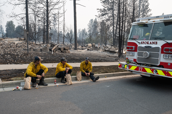
SEATTLE — More than a dozen major wildfires continue to burn across Washington, with many of them growing fast over the weekend.
They’ve destroyed hundreds of homes and continue to imperil many more as they chew through the state’s landscape and communities. Tens of thousands have been forced from their homes. Many still have no power.
Already this has been one of the most destructive wildfire seasons in the state’s history, with over 700 structures destroyed in Spokane alone over the weekend and a nearly 30% increase in the land covered by wildfires in the past few days.
And months still remain in Washington’s wildfire season.
The Kaiser Canyon wildfire on the Colville Reservation and north of Grand Coulee Dam, is the largest in the state at more than 136,000 acres, or 212 square miles. To the east, the Modrite fire has grown to cover nearly 78 square miles.
The Little Giant fire appeared to have jumped the width of Lake Chelan over the weekend, leading to new “Go Now!” evacuations on the east side of the lake, north of Manson. It’s now burning about 60 square miles north of Leavenworth.
The Sinlahekin fire in north-central Washington has grown to nearly 116 square miles and now burns much closer to the town of Tonasket.
Conditions have been building toward this moment in Washington for years, and they’re growing worse. Extreme drought and heat set the stage, said Cody Desautel, executive director of the Confederated Tribes of the Colville Reservation. The reservation in northeast Washington has been among the hardest hit by wildfires in recent years.
State officials declared an unprecedented fourth consecutive drought emergency this year, marking a new low for the state’s water supply. Low mountain snowpack, early melt-offs and record temperatures have all cut into Washington’s reservoirs, rivers and streams.
One snowpack monitoring site tracked by Colville scientists typically records 6 to 8 feet of snow each winter. But by February it had seen only inches, Desautel said. Nor did it improve meaningfully in the months that followed.
This is part of an ongoing warming trend, in which Washington’s precipitation increasingly falls as rain rather than snow. This translates to more water when the state doesn’t need it, and less water when it’s needed most.
Shoulder seasons are shrinking. Summers are starting earlier, becoming hotter and drier.
That means the moments in which Colville crews can move into the forests of northeastern Washington to safely light prescribed fires are becoming shorter, Desautel said. The practice is one of the few tools these areas have to strategically reduce the grasses, shrubs and trees that might otherwise fuel major wildfires.
The first wildfire on the Colville Reservation sparked before Father’s Day, several weeks earlier than normal, Desautel said. Now about 200,000 acres, or over 300 square miles, have burned across the reservation. Recovery efforts are underway while firefighters continue to try and stop the flames from spreading further.
Days when wildfire risk is the highest — known as fire-weather days — have increased in northeastern Washington since the early 1970s, said Shel Winkley, chief meteorologist for the nonprofit Climate Central. On average, the region now sees about 21 more fire-weather days each year than it did more than half a century ago.
And Washington’s rainy season creates a sort of “weather whiplash,” Winkley said: Wet periods allow for foliage to grow, while hot and dry summers turn those grasses, trees and shrubs into tinderbox conditions.
These wildfire conditions are growing not only in Washington but across the world. Wildfires are burning across much of the American West right now and devastating fires threaten areas in France and Spain that haven’t historically seen these types of natural disasters.
Some wildfire ecologists warn the extended burning season will continue to raise the wildfire risk west of the Cascades and into some of Washington’s wettest regions. These areas have seen large wildfires throughout history, but typically the duration between major events has been much longer. Last year one of Washington’s largest wildfires burned on the Olympic Peninsula, with a smoke plume in view of downtown Seattle.
Last week, wildfires across Washington covered a total of perhaps 547 square miles, said Thomas Kyle-Milward with the state Department of Natural Resources. But as warm, dry and gusty conditions blew across the state, that figure grew nearly 30%. Now all the state’s wildfires cover “comfortably” over 700 square miles, he said.
The forecast for the coming week shows highs in the 90s, with not a drop of rain in Spokane.
©2026 The Seattle Times. Visit seattletimes.com. Distributed by Tribune Content Agency, LLC.






Comments