Colorado wildfires: Aspen Acres fire 13% contained, new evacuations for Willow fire near Leadville
Published in News & Features
New mandatory evacuations were ordered Sunday morning for a nearly 4,000-acre wildfire burning near Leadville in Lake County, and a large swath of residents was placed on pre-evacuation.
The Willow fire is one of four active fires in Colorado that together have consumed more than 160,000 acres, forced thousands of evacuations and destroyed hundreds of buildings, including homes. The combined burn area of the Willow, Aspen Acres, Gold Mountain and Ferris fires is roughly 250 square miles.
As of Sunday morning, the Snyder fire burning along the Colorado-Utah border was nearly contained, according to fire officials. The wildfire killed three firefighters and consumed roughly 30,200 acres — or 47 square miles — west of Grand Junction after it sparked on June 27. It was estimated to be 95% contained on Sunday.
Together, the five wildfires have scorched more than 190,000 acres, or 297 square miles. That’s nearly twice the size of Denver.
Jump to: Aspen Acres fire | Gold Mountain fire | Ferris fire | Willow fire | Air quality alerts
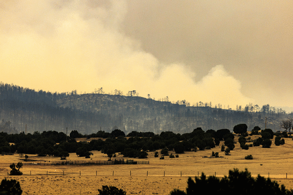
Aspen Acres fire in Custer and Pueblo counties
Colorado’s largest active wildfire, which sparked last Monday near the Aspen Acres campground, has destroyed hundreds of homes and evacuated thousands of residents.
As of Saturday, the Aspen Acres fire had consumed 86,983 acres, or 136 square miles, and was 13% contained, according to fire officials. At that time, it was the eighth-largest wildfire in Colorado history, roughly 300 acres behind the 2012 High Park fire, according to records from the Colorado Division of Fire Prevention and Control.
The High Park fire destroyed 259 homes and killed one person.
Fire officials said the infrared flight was unable to map the Aspen Acres fire overnight because of thunderstorms, so no updated acreage was available Sunday morning.
Pueblo County officials estimated Saturday that the Aspen Acres fire had destroyed more than 200 homes between Pueblo and Custer counties, but damage assessment teams haven’t been able to assess the full burn area because of the active fire. More than 800 personnel were on scene Sunday morning to fight the fire.
Thousands of people remained under evacuation orders in Pueblo and Custer counties on Sunday, and pre-evacuation warnings were in place in Fremont and Huerfano counties. Rough boundaries of the mandatory evacuation zone include:
—To the north: Colorado 96 between Wetmore and Pueblo
—To the east: Red Creek Springs Road at Colorado 96, then from Bronquist to Colorado 78, Muldoon Hill to Burnt Mill; South Burnt Mill Road to Interstate 25; and I-25 to Huerfano County
—To the south: Huerfano-Pueblo county line
—To the west: the Custer-Pueblo county line to County Road 371, then Colorado 165.
Communities under evacuation include Colorado City, Red Creek Ranch, the North Creek area, Aspen Acres, 12 Mile Road, South Pine Drive, Beulah, Rye, San Isabel Lake and Bishop Castle. Updated evacuation information is available online.
Evacuated residents can seek shelter at the Pueblo County Recreation Center, 1650 Cooper Place; the Wetmore Community Center, 95 County Road 393; or at Pathfinder Park in Florence, 6655 Colorado 115.
As of Sunday morning, according to the Colorado Department of Transportation, road closures included:
—Colorado 96 in both directions between Silver Cliff and Siloam Road west of Pueblo
—Southbound Colorado 67 between the Fremont County line and Wetmore
—Colorado 165 in both directions between McKenzie Junction and I-25
—Colorado 78 in both directions between Colorado 165 and Rock Creek Road west of Pueblo
Northbound Colorado 67 and Colorado 96 are open for people evacuating Wetmore but remain closed to all other traffic, according to state transportation officials.
The exact origin of the fire remains under investigation, but officials believe it was human-caused.
Firefighters’ primary concern on Sunday will be afternoon thunderstorms, which could bring lightning and erratic winds, according to an update from the fire’s complex incident management team.
Rain from storms may be beneficial, but heavy rain can also cause flash floods and road damage in severely burned areas, officials said in the update.
Gold Mountain fire near Ouray
The Gold Mountain fire, which has consumed thousands of acres since it sparked eight days ago, is burning on mountainous terrain north of Ouray with no containment, fire officials said Sunday.
As of Sunday morning, the Gold Mountain fire had scorched 26,405 acres, according to Rocky Mountain Area Complex Incident Management Team 3, which was leading the fire response. That’s roughly 41 square miles.
More than 800 firefighters were on scene Sunday morning to fight the wildfire, which started on June 27, according to fire officials. The cause of the fire remains under investigation.
Mandatory evacuation orders remain active north and west of the fire, according to Ouray County’s evacuation map.
The southern evacuation zone includes Lake Lenore and is bordered to the west by U.S. 550, to the north by Cutler Creek, to the east by the wildfire burn area and to the south by Bridalveil Creek. The northern evacuation zone is bordered to the west by Ouray County Road 8 and Ouray County Road 10, to the north by Tommy Creek, to the east by Lou Creek Pass and to the south by Baldy Peak and the wildfire.
Evacuated residents can seek shelter at the Ridgway Secondary School, 1200 Green St., according to county officials.
Federal officials also ordered closures on Bureau of Land Management land and in the Grand Mesa, Uncompahgre and Gunnison National Forests.
Ferris fire in San Juan National Forest, near Dolores
The Ferris fire had consumed 42,758 acres as of Sunday morning, or 67 square miles, according to San Juan Incident Management Team 8. At that time, the fire was estimated to be 7% contained.
The containment estimate declined between Saturday and Sunday because of the wildfire’s growth.
More than 500 personnel were on scene Saturday night to fight the flames, according to the incident management team.
The Ferris fire started as three separate fires, all sparked by lightning in the San Juan National Forest on June 27.
Mandatory evacuations remained in effect Sunday for residents east and west of the wildfires, according to the Dolores County Office of Emergency Management. The eastern evacuation area was bordered to the north by Disappointment Road, to the south by the Glade Ranch community, to the west by the fire and to the east by Lone Mesa, according to the office. The western zone was bordered to the north by County Road J, to the south by County Road S, to the west by Cahone and to the east by the Bradfield area.
The U.S. Forest Service also closed the Bradfield Bridge Campground, Forest Service Road 504 to the base of McPhee Dam, Forest Service Road 521 and Forest Service Road 504 “out of an abundance of caution,” federal officials said.
Colorado Parks and Wildlife closed public access to the Lone Dome State Wildlife Area in Dolores and Montezuma counties.
Willow fire near Leadville
New mandatory evacuation orders were issued Sunday morning for the Willow fire burning in Lake County, according to the sheriff’s office.
The Sunday morning evacuations in Lake County included County Road 11, County Road 11A and the Lake Fork Trailer Park, sheriff’s officials said. Additional pre-evacuation orders included:
—The Twin Lakes area
—The Pan-Ark Subdivision
—EE Hill
—Colorado 82 west to the summit of Independence Pass
—The Mount Elbert Forebay Reservoir
—U.S. 24 between milemarker 180 and milemarker 186
—County roads 10, 24D, 44, 45, 46 and 136
—Forest Service Road 130
—Valley Road
—Crystal Ridge Road
—Loop Road
—Stargazer Circle
As of Sunday, the Willow fire was burning on an estimated 3,957 acres with 1% containment, according to fire officials. That’s just over 6 square miles.
“Active fire behavior” is expected Sunday, especially as thunderstorms bring strong winds into the area, according to an update from Southwest Area Complex Incident Management Team 4, which is leading the fire response.
The evacuation zone is bordered to the north by Lake County Road 9A, to the east by Lake County Road 25 and U.S. 24, to the south by Echo Creek and to the west by Twining Peak.
Air quality alerts
Wildfire smoke has consistently worsened air quality across Colorado over the past week, prompting state health officials to issue air quality advisories.
The newest alert from the Colorado Department of Public Health and Environment will remain in effect until at least 9 a.m. Monday, according to the agency. That alert covers Alamosa, Chaffee, Custer, Delta, Dolores, Fremont, Gunnison, Hinsdale, La Plata, Lake, Mineral, Montezuma, Montrose, Ouray, Park, Pueblo, Rio Grande, Saguache, San Juan, San Miguel and Summit counties.
If the smoke drops visibility to less than 5 miles in an area, it has reached unhealthy levels, according to the agency. Those with heart disease and respiratory illnesses, young children and older adults are more at risk.
_____
©2026 MediaNews Group, Inc. Visit at denverpost.com. Distributed by Tribune Content Agency, LLC.


Comments